Friday, October 18, 2013

Exploring Provo - Slate Creek Canyon.

After traveling for so many days it was good to stop and grow temporary roots for a day or two.  It's nice to sleep in and not have to drive any distance except for locally.  My driving now consisted of two trips - (1) the Seven Peaks Ice Arena, and (2) a Provo Parks and Recreation Trailhead.  My routine was pretty simple - eat, sleep, watch ice hockey, and take a walk with Rocky.

The evenings were filled with cheering on the Utah State Aggies ice hockey team as they played Denver University, Boise State University, and Montana State University.  The "Ice Aggies" handily defeated each team so that was a bonus.  Denver University and Boise State University were particularly interesting games with plenty of goals and action.  I love watching live ice hockey.

My first full day without having to drive had me and Rocky interested in taking a walk, not just a walk, but a long walk were he could run free and sniff.  Both of us could work out those three days of "car legs and butt" that we had earned.  I looked at a map and initially it didn't show much.  There was a city park less than a mile away - Bicentennial Park.  So Rocky and I went to Bicentennial Park.  Ugh. This was simply a facility for young mothers to let their young children play.  This was no park for a dog.  Okay, where to now?

As I was traveling to Bicentennial Park I spied a road sign that said, "Lightning Peak."  I traveled the road but saw no other reference to Lightning Peak.  What I did see though is some rocky outcroppings on the Wasatch Mountains that closely bordered Provo to the east.  Hmm? I thought, that rocky peak looks like it could be a Lightning Peak.  As I drove along literally the base edge of the Wasatch Mountains I saw a turn off to a Provo Parks and Recreation site.  I drove up the very rocky and steep grade and decided to park my truck off to the side of the road and go explore further by foot.  What I discovered was that if I would have ventured another 100 yards I would have come to a nice paved parking lot.  Funny, a nice paved parking lot but to get it you need a 4 wheel drive vehicle.  Anyway I surveyed the area and found a nice wide trail - the Bicentennial Trail - that parallels the valley and the base of the Wasatch Mountains.  Rocky and I walked about 1/2 mile out to a promontory to get a view of the Utah Valley.  From this promontory you could see Utah Lake, and the entire Utah Valley north and south.  The city of Provo and Brigham Young University laid at your feet.  Quite spectacular.
Panorama view of Utah Valley from the base from the Bicentennial Trail by Slate Creek Canyon

Looking west up Slate Cr. Canyon
Looking back towards the Wasatch Mountains you could see a steep canyon that rose high up to some lofty, fresh snow covered, mountain tops.  You also got a great view of the rocks which I thought (and still think) are Lightning Peak.  Not satisfied with our short promontory walk, Rocky and I decided to explore Slate Creek Canyon.

Slate Cr. Canyon trail and what I think is Lightning Peak
The trail started out steep, very steep.  I would estimate an 8-10% grade at least.  I had to stop several times to catch my breath.  My thought was that because it was so steep, we would only travel a short distance up and then turn around.  I turned on my Google My Tracks app on my smartphone to record my distance and travel.  What I discovered was that my curiosity was getting the best of me.  I found myself saying, "Okay, just to the next corner and I'll turn around" or "Just to the next flat spot (relatively speaking) and I'll turn around." What happened was that I kept on going up and up the canyon and reveling in the canyon beauty. The leaves were all turning color from yellows to deep reds.  The sky was incredibly blue.  Several times I checked the My Tracks app to see my distance.  My new resolve was to go one mile up the canyon.  I pushed hard as it seemed the trail was getting steeper.  Finally, I spied a somewhat less steep spot which I deemed was a "flat spot" and turned around.  I had traveled farther 1.05 miles but I was panting so hard that I realized it was time to turn around.  Even Rocky's tongue was dragging and he too probably relished going down hill.

The sun shining on the canyon walls intensified the colors.  I kept on going up and up, each panting breath had me taking another step.  I stopped and dropped off my sweatshirt and hat realizing they were not needed and it was useless to lug them up with me when I knew I would be turning around. Several times I stopped and checked the


Going down Slate Cr. Canyon.
Going down hill was not as fun and as easy as I thought it would be.  The steepness required me to ensure that my footing was good with each step so I didn't ski on the gravel and end up on my butt. I noticed that each step was like hard breaking to slow my downward momentum.  I found that not only did I have to stop on my way up, but I had to stop to rest my knees and calves on my way down.  I found my dropped off sweatshirt and hat but realized I had traveled farther than I had thought. As I continued my legs started to get wobbly, my calves and knees were aching from the boom-boom-boom of my body pounding down on the ground to slow my descent. I finding myself wishing I hadn't gone so far.  But despite my whining, all I had to do was look up and around the canyon beauty to quickly and temporarily forget the agonizing descent. My gosh this is just so beautiful.

Finally, I reached the upper parking lot and then the last descent to my parked truck and the walk was over.  I do a lot of walking and felt that with this walk I had truly accomplished something.  Though my legs were aching I felt fully physically and emotionally refreshed.  Wow! What a walk.  If you ever find yourself in the Provo area I would highly recommend this hike.  A USFS sign said that the Slate Creek Canyon trail ventured up for about 3.6 miles where it connected with some other trail.  I believe it would be beautiful in the early spring when the creek would be flowing with water from melting snow.  There are no bridges and in the mile I went the creek was crossed about three times, so you would have to have some good waterproof boots.  The trail would be too hard to hike if there was snow or ice, and way too hot to hike in the middle of summer.

Finally my legs continued to shake and recover for the rest of the day and well into the evening.  I thought I was in fairly good shape by exercising three times a week, but this hike indicated otherwise. My explorations of Provo were otherwise fairly limited - motel-ice rink-motel and Slate Cr. Canyon. Not sure there was much else to see that didn't already look like any other town.

Thursday, October 17, 2013

Day 3, Elko, Nevada to Provo, Utah via the Mormon Trail

Ugh, Nevada. Beautiful in its own way.
After a quick fast food breakfast I continued on to Interstate 80 and my eastward trek. Pretty much the same as yesterday, scrub-sagebrush and mountain range-valley-mountain range scenery all the way to Wendover. Wendover seems like quite the desert hot spot with all the casinos. I had no interest in stopping at this over-commercialized sin city called Wendover. From what I could tell the place was jumping from all the cars and tour buses.

Today's route was, I 80 to Utah State Route 196 for 183 miles. Then down UT SR 196 for 19 miles and turning left onto UT SR 199 for 22 miles. A right turn at the small town of Rush Valley onto UT SR 36 for 39 miles. UT SR 36 ends and a left
Yellow highlight marks Day 3's travels
turn onto US Hwy 6 for 24 miles going through the towns of Eureka and Santaquinn, Utah. Finally a left onto I 15 N to Provo (19 miles) and my planned stay at the Sleep Inn Motel. I chose this route which avoided Salt Lake City for several reasons. One, was I wanted to avoid Interstate highway driving as much as possible. It is just so boring. Two, I wanted to avoid the high stress driving on Interstate highways when in cities. There's just too many cars and trucks driving, entering, and exiting the freeway. And three, it would get me to Provo too soon - well before check-in time at the motel. What was I supposed to do while waiting in a city that I was unfamiliar with? Sure driving this route was farther and slower but it would meet my objectives and be more interesting.

Driving from Elko to Wendover was, in a word, boring. Endless sagebrush and only very distant mountains. I consumed at least a couple of cups of coffee to stay alert. It was at this point when I started listening to country music radio. There were no rock-n-roll stations that came in clearly. The only other radio stations that seemed to come in clear were religious. Ugh, I decided to take the lesser of two evils - country music. It wasn't long when I, believe it or not, I started to like it. What the? Country music? I found that country music told a story in song. I liked that.

Coming down the hill into Wendover you could see the impressive salt flats stretching for miles. Water
Bonneville salt flats as viewed from I 80
on the salt flats was shimmering in the morning sun. I didn't expect to see so much water. It didn't look deep, only a few inches. Then I thought well duh, that's how the salt flats got there. I was enamored with gawking at the salt flats that I missed the exit to the Bonneville Speedway. Surely I thought there would be another exit but I was wrong. There wasn't another exit for 22 miles. So all I could do was observe from the truck the endless salt flats. There was no highway right-of-way fence preventing you from cutting across the median or driving off the freeway. You could see that several others had done so. I chose not to, because I didn't want to risk getting stuck, so on I drove. I noticed that folks had scribed in the salt-sand-mud things. There was even some primitive artwork of bottles, sticks, and junk stuck into and arranged in various patterns alongside the Interstate highway. I did so want to touch or drive on the salt flats. I guess I'm going to have to come back another time.


Interesting stone arch at the Wild Horse Hills rest area
I pulled over at Wild Horse Hills rest area just on the eastern edge of the salt flats. Rocky and I took a short walk to some rocks in the distance. A sign said, "Beware of rattlesnakes and scorpions" which had me a bit more observant on walking through the rocks and brush.  Rocky enjoyed the romp-about. We saw no snakes or scorpions, nor did we see any wild horses.

We continued on I 80 which was absolutely boring. So at the first chance to get off and take a scenic route I jumped at it. The opportunity came to go south on Utah 196 or Skull Valley Highway. It was just what I needed a narrow two lane road with a beautiful range of mountains that had a fresh topping of snow off to my left. Off to my right was a scrub-sagebrush valley. I saw an interesting road sign that warned me off free range buffalo. I never saw any buffalo but did see some prong horn antelope. The road turned without warning right into the US Army Dugway Weapons Proving Grounds. The only other structure was a large Latter Day Saints church. No other buildings. Weird I thought, but then I am in Utah. Rather than approach the gate I did a U-turn right in the middle of the road. As I completed my turn, I noticed I could go onto Utah 199. Huh? No sign or anything indicating Utah State Route 199.


Utah SR 199 looks like a 'road to no where'
Utah 199 seemed to go straight into a mountain range. I started humming the Talking Heads song, "I'm On A Road To Nowhere." For miles you couldn't see any sign of the road going over the mountains, but the road did. The road went in to a canyon climbing and twisting through a juniper forest until once again you came to pass. Just east of the pass there was a small campground but it was empty. The road steeply and twistedly wound its way down to the valley below. What I didn't realize was that I was on a road called "the Mormon Trail." The road or trail ended in a small town called Rush Valley. 

I turned right on to Utah State Route 36 going towards Vernon, Utah. To my left was another US Army facilty the Tooelle Weapons Storage Dump. It looked very similar to the Army weapons storage dump at Hermiston, Oregon - half underground bunkers arranged in rows. I later found out that Tooelle was not pronounced "too-lee" rather "too-ell-lah." Perhaps the residents didn't want to be known as living in the "too-lees" because it looked like you should pronounce it like that. Highway 36 wound its way past Vernon (a former Pony Express stop) and through sparse sage and juniper country until it came to its end at US Highway 6.

I turned left onto US 6 and once again started a climb up and over a small mountain range. This time at
A pass looking into another valley on the Mormon Trail
the summit was the town of Eureka, a small former mining town. The town proudly displayed some mining equipment to celebrate its history. Curiously there were large gray rocks, about the size of baseballs neatly distributed everywhere - hillsides, along the road, around the school, in tiwn around businesses, and even around homes. I wondered what mining would result in that rock as a tailing? The rock did not resemble the surrounding rock. I pulled into a garishly painted bright yellow and red cafe called the "3 Prospectors Cafe." As I entered there was a vigorous conversation going on about chainsaws, chainsaw chains, and cutting wood. Seems that juniper is tough wood and wears chainsaw chains down rapidly. So, if you are going to cut juniper, bring spare chains. I ordered the special - beef tips, gravy, over noodles. It was quite good and better than a hamburger. I asked about the rocks all over town. They explained that gold, lead, and other metals were mined in Eureka. The mine petered out in the late 60's. Tests showed that the resulting tailings were toxic to people and the environment.  They thought of cleaning all the tailings up, but decided the cheapest thing to do was bury it under rock. Wow, that's a lot of rock. I asked what keeps the town alive now? Hunters and tourists.

After Eureka, US 6 dropped rapidly into the Utah Valley. The seemingly impenetrable Wasatch mountain range towered over and framed the eastern side of the valley. The valley contained Utah Lake as well as several towns and cities, namely Provo my destination. I drove through Santaquinn and turned left onto I 15 headed for Provo. Once again it took me a minute or two of adjustment from traveling two lane roads at 55 mph to four lane roads at 75 mph. Also from no traffic to bustling traffic of cars, trucks, and semis.

I made it to my motel, checked in, and prepared for the next adventure of the day - a collegiate hockey game. I had traveled over 306 miles and once again saw sights and scenery that was all new to me.

Wednesday, October 16, 2013

Day 2, Clyde Holliday State Park, Oregon to Elko, Nevada

Oh my, it got cold, very cold, last night although I am unsure of exactly how cold but for sure in the low 30"s maybe lower. That portable alcohol heater sure did its job of keeping my sleeping area warm. In fact, some time in the night I woke to turn the heater off, only to turn it back on.  This Origo heater is invaluable.  I was so nice and warm I didn't want to get up. I kept on waiting for the sun, but then realized by being in a valley it could be some time before the sun's rays hit my camp.

I warmed up by heating up water for coffee and instant oatmeal. It was so cold I had to put gloves on. I'm sure my neighboring campers were amused watching me as they sat in their big travel trailers all nice and warm. I wished I was too. I wolfed down the coffee and oatmeal. I then heated up the rest of the coffee to boiling hot and re-filled my thermos. Camp was easy to break. Move the stuff from the cab to the back and I was done.

I didn't register or pay for my campsite last night so Rocky and I took a walk to register. Then we walked farther along the John Day River on a nice park trail. Several times we saw deer out feeding. They were probably using the state park as a refuge to keep from being hunted as it was hunting season. I noticed that it definitely got cold because there were many places you could see where water in small puddles, ditches, and ponds had a thin layer of ice. The coffee, oatmeal, and brisk walk were warming me up. When I left Clyde Holliday State Park the truck temperature gauge showed a low of 29 F. Okay, it is officially cold.

After leaving Clyde Holliday State Park shortly after 8 AM, I entered the small town of John Day. I decided to get gas because this was the last town of any size until I got to Winnemucca, Nevada almost 300 miles away. In this distance I only went through three small towns, if you could call them that. Actually they really were a collection of a few houses (less than 10), a grade school, mercantile, and a post office. Lots of vacant buildings which let you know that sometime in their past they were bigger and more significant than they are now. The three towns were Frenchglen, Fields, and Denom. Denom actually straddled the Oregon-Nevada border and was the sorriest looking of the three.  You could tell Frenchglen had some former history to it and still had a thriving elementary school.  Fields seemed to be more of a hunters destination, although the elementary school seemed smaller. Perhaps Frenchglen or Fields had gas but it wasn't obvious. Denom didn't have anything - school, post office, store or bar. In fact, I wonder considering the shape the town was in, why would anyone choose to live there.
Day 2 route is yellow highlighted
Today's route was, US Highway 26 to the town of John Day, about 7 miles. Turn right on to US Highway 395 all the way to just outside of Burns (about 67 miles) to turn off onto OR SR 205, the Frenchglen Highway. Frenchglen being about 60 miles away. Staying on OR SR 205 for 73 miles until the Oregon-Nevada border where OR SR 205 became NV SR 292. Three miles down NV SR 292 where it becomes NV SR 140. Travel 65 miles on NV SR 140 with several very long straight stretches until it hits US Hwy 95. A right turn onto US 95 and 31 miles later you're in Winnemucca, Nevada. A left turn onto Interstate 80 and 124 miles later you are in Elko.
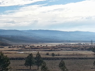
Silvies Ranch country along US 395 heading south

Between John Day and Malheur the scenery was typical of the day before. A winding this-way-that-way road up a canyon until it hit a high point in the woods. Basalt columnar cliffs and large out croppings of basalt rocks mixed in with willows along the canyon creek and Ponderosa pines everywhere else. The Silvies Ranch before I got to Burns, Oregon, seemed to go on for miles. I noticed that the ranch had several huge barns or sheds that always featured three evenly spaced characteristic cupolas on the roof. Also, the gateways to the ranch were stucco arches versus typical log gateways. US 95 bisected at least 12 or more miles of the Silvies Ranch.

Just before Burns, US 95 started dropping out of forested country and into high desert scrub-sagebrush with steppes and buttes. Malheur Lake was shimmering in the morning sunlight. I considered stopping at Malheur Wildlife Area but it was closed due to the government shutdown. Malheur is famous for observing waterfowl. OR SR 205 bisected the western edge of the Malheur reservoir. I slowed down but didn't see any waterfowl. What I did have to stop for was a cattle drive across the road. Now how often does that happen to you?  I was most intrigued how the two Border Collies did all the work to keep the cattle in line. They wandered this way and that way stopping every now and then. The cowboys on horseback simply rode along at the cattle's pace. Wow! Might not seem like much but I found that fascinating and a most welcome diversion.

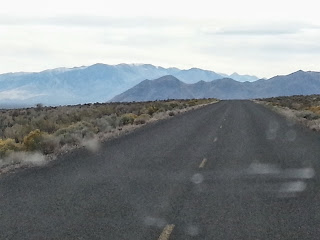
High desert and mountains. (Photo taken through windshield.)
After Malheur the drive changed from following along a creek and canyon to driving along the edge of shallow lakes and wide valleys. A familiar pattern of mountain range-valley-mountain range became the norm. The road would follow along or slowly cross a valley, then at some point reach the far mountain range before going into the next valley and so on and so forth all the way to Elko, Nevada. Some mountain ranges had big mountains, other ranges the mountains were simply hills. When you would cross a mountain range the road would rise sharply and wind its way up and down and over the range. Driving the valleys consisted of long straight sections with a slight curve just to keep absolute driving boredom at bay.

Off to my left as I headed south to Frenchglen was Steens Mountain. This mountain seems to just rise up out of the steppes. I read that it is its own ecosystem. I observed plenty of snow up on Steens Mountain. Just before Frenchglen there even was a skiff of snow alongside the road; although I was many miles from Steens Mountain. At Frenchglen I saw a turn off to the "Steens Mountain Loop Road." I decided that traveling the Steens Mountain Loop Road was on my bucket list.

SE Oregon on OR SR 205 just outside of Frenchglen
Right out of Frenchglen OR SR 205 steeply climbs with many twists and turns to get out of the valley to get back into that high desert. Once at the summit the road straightens out back to the familiar boring straights. I wished I had stopped in Frenchglen but not sure why I didn't. So I will have to return at some other time.

There was no traffic until I hit Interstate 80 at Winnemucca. Many times I stopped barely pulling off
Sagebrush and empty spaces
the road to either get a picture or take a pee and for the whole time - maybe 10-15 minutes there was no other vehicle. I began to wonder what to do if an unfortunate mechanical issue would arise. You could get old waiting for another car. When you did stop, it was so quiet.  A few stops had some wind blowing, but I heard no birds or other critters. I saw a few Marsh Hawks (you can tell by the white rump patch) and a few Ravens from time to time. I would watch as I drove the Marsh Hawk hover spying some prey below, but never saw the drop for the kill. Hmm? The Ravens were always in pairs. Was I missing something?  Of course there were road signs warning drivers to be on the lookout for wildlife. Oregon had the most boring signs, e.g., Elk, Deer, Livestock, etc. Nevada's road signage seemed to have action images of cows, antelope, and deer.  Come to think of it, I didn't see any bullet holes in Nevada road signs whereas Oregon road signs resembled Swiss cheese.

My traveling of state highways ended when I reached Winnemucca and the end of Nevada 140 which used to be Oregon 205. From Winnemuca on it was even more boring high-speed Interstate freeways. I had to put the pedal-to-the-metal too, from leisurely 55 mph to now blistering Interstate speed of 75 mph. What's more, from never seeing another vehicle to now having multiple vehicles - cars, trucks, and semi-tractor trailer rigs - share the road alongside of you. Wow, I had to stay in my lane. The only positive was having to share the road with other vehicles was your only relief from total boredom of driving in Nevada. All mountains seem to look the same, as well as endless scrub and sagebrush. I don't remember seeing any trees except those planted around houses. Uh, not houses but manufactured homes surrounded by multiple vehicles in various states of disrepair. Used travel trailers (mostly dilapidated) seemed particularly endemic to the Nevada landscape.

Elko is kind of an oasis in the middle of a the high desert scrub-sagebrush. Of course being Nevada there are casinos. Tonight I am moteling it since the overnight forecast was for temperatures in the 20's. Also, Rocky and I prefer a comfortable bed versus the bed of a truck if it's going to get that cold. I pulled into a Motel 6 and got a room for the night. I don't mind the simplicity of Motel 6, but I like them because they are pet friendly and cheap. I ate a quick supper then retired. I was tired, perhaps from driving, perhaps from last night's camping, or whatever but I didn't stay up too late. It was a good day. Traveled over 430 miles and saw lots of places that I had never been to.

Tuesday, October 15, 2013

Day 1, Olympia, Wa to Clyde Holliday State Park, Or


I'm a bit nervous about this trip. It has been quite sometime since I did such a trip on my own.  I believe the last was on my way to Yellowstone National Park in June, 1976. That was 38 years ago. That trip was to start a summer job, this one is to see some of my son's collegiate hockey games. The trip is planned around traveling several roads that I have never been on and visit areas I have never been to. Areas like Malheur, Steens Mtn., Bonneville Salt Flats, and Bear Lake. I will be traveling to and through places like John Day, Frenchglen, Winnemucca, Elko, Rexburg, and Salmon. My traveling buddy will be Rocky my blue heeler. I've got to finish packing versus blogging.
Delphi Road near Olympia heading south
Just before I left, Rocky went out in to the street and challenged a guy walking his dog. He was mad. Then I was mad. This had me bugged for most of the day.

We got underway at 10:22 AM. I drove south through back roads to Littlerock to get to I-5. I didn't drive long since I had to get gas at the ARCO in Rochester. $3.29/gal - that's cheap. It's still quite foggy but it's supposed to clear up. No sooner did I think that, when just after Chehalis - about 10 minutes later - fog lifted and I had clear, sunny skies for the rest of the day.

I continued down Interstate 5 until I got near to Vancouver where I left I-5 to go south on I-205 and exited on to Washington State Route (SR) 14 East.  Wa SR 14 is a beautiful way to drive up the Columbia River. WA SR 14 goes along north side of Columbia River and is two lanes, and I-84 is an interstate freeway that follows the south shore of the river. WA SR 14 is just not as fast as if I were to travel I 84 on the south side of the Columbia. But, I wasn't in a hurry.
Outside of Bonneville Dam on WA SR 14
Traffic on WA SR 14 was very light and I was making good speed and time; of course I have to remind myself that it is a Tuesday in middle of October. As I wound along and drove higher along the hills and buttes the maples really turned color - lots of yellows and reds. Driving lower along the river the trees were more green and only had touches of yellow.  As I headed east, oak trees started to become mixed in with the maples until you got to a point where there were no more maples but only oaks. This subtle transition signals the change from west side to east side. In time as I drove farther east the trees got less and less until there were no trees. Then I started to notice the transition from grasses to the definitely drier vegetation of sagebrush. I love driving along the Columbia because of this gradual spectrum of going from wet-west side to the dry east side.

An east wind coming right down the gorge was blowing hard, must've been 20 knots or more. I stopped
View of Columbia River from Cape Horn on SR 14
for a moment to get a picture at Cape Horn scenic view.  The road here must be over 1, 000 feet above the river. You can look up river at least 20 miles or more. The river definitely showed the wind blowing by creating long ribbon patterns of spray and waves on the water. Somewhere after the town of Stevenson the wind lessened and by the time I got to Bingen there was no more wind. In fact, there were beautiful reflections of the mountains in the sloughs that border the river.

I I turned off of WA SR 14 onto southbound US 97. crossed the Columbia River and left Washington state and in to Oregon. US highway 97 is a major north-south route serving central Washington and Oregon communities. Immediately across the bridge is the Interstate community of Biggs Junction. Biggs is a popular stop with travelers both pleasure and commercial and makes its name by intersecting I-84 and US highway 97. Because I was starting to travel in eastern Oregon where the towns and the availability of gas is less I decided to fill up with gas. Not so cheap here - $3.45/gal.
 
US 97 winds south up a twisty canyon that takes you away from the Columbia River. Nearing the crest of the canyon, I turned off of US 97 and left onto OR SR 206. Almost immediately you are in the old farming community of Wasco. Wasco is a small town but still "alive" with homes, a church, and a farmers supply store. After Wasco, OR 206 continues to gently climb up through the wheat fields and into a forest of windmills. Some windmills were turning others not. Again the wind was very light.

At about milepost 10 on OR 206 winds its way steeply down a canyon for four miles until it comes to Cottonwood State Recreation Area; then twisting and turning five miles back up out of Cottonwood canyon. There were plenty of 25 mph corners in and out of the canyon. Finally at milepost 24 you were fully at the summit and the state route bisecting various wheat fields. OR 206 ends in the small but vibrant farming community of Condon. In Condon I turned right onto OR SR 19.

I loved the little town of Condon. Condon was fully decked out in Halloween figures at various points in town, along with flags and banners welcoming you to Condon. Wow, there's life and pride in this little farm town out in the middle of nowhere. Sure it was a Tuesday sunny afternoon, but there were people walking its sidewalks and out chatting with others.  It looked as if I was witnessing various Norman Rockwell paintings as I drove through town. Again, I really fell for this little town.
Beautiful Oregon State Route 19
Once out of Condon, OR SR 19 descends gently down into another canyon, the road twisting this way and that way with plenty of 30 mph corners. Almost imperceptibly the expansive wheat fields changed into sagebrush and juniper trees. There were more hills and the hills weren't round like they were along the Columbia River, but rocky steppes and buttes. If you didn't pay attention, ever so subtly the scrub-juniper landscape morphed into Ponderosa Pine forest and the hills much more pronounced even becoming small mountains. The mountains continued to get bigger and more dramatic in color - the mountain rocks and soils were green-gray, pink to red, and dark browns and blacks of basalt. Conversly, on the "down-low," OR SR 19 drove along the John Day River with its alternating riffles and pools. Bordering the river trees in fall colors of reds and yellows added even more color. Driving was almost dangerous because I was so caught up observing the terrain and colors. The only distraction is the town of Spray - another little community out in the middle of nowhere with a lot of pride. After the little town of Spray, OR SR 19 continues to follow along the John Day River and enters John Day Fossil Bed country. Again vividly colored mountains and soils rise up each side of the river canyon until you think
John Day fossil bed country
you cannot go any further but you do. OR SR 19 ends abruptly and you have no choice except to turn left or right onto US highway 26.  I thought where did this highway come from? I turned left into aptly named "Picture Canyon" on Highway 26. The highway winds through almost vertical rock walls and suddenly, and I mean very suddenly, emerges out of the canyon into a gentle valley. To the north mountains have shrunk into hills. To the south there are still mountains, but they are more distant and not rising so dramatically right from the river.  The broad valley is filled with small farms and homes. One of the small communities I passed through was Dayville whose claim to fame is the fossil beds. Next up was the small town of Mt. Vernon. General Store, cafe, farm supply, and Post Office describes each town.

The sun was setting behind the mountains making evening seem to come too soon. I was anxious to get to the Clyde Holliday State Park campground and get settled. Finally there was the turn into the campground.  What a beautiful campground. I easily found a site. The only others camping were retired folks and hunters. My camping arrangement was simple - sleeping in the back of my truck. I've got a short pickup bed, and I'm still pretty tall so I had to configure my bed (a sleeping bag on top of a big chaise lounge mattress) to lie cross-wise on the truck bed. Rocky would lie in the space to my right.  I positioned the heater to my lower left and opened the canopy window right above it so I wouldn't suffer from carbon monoxide poisoning. The other camping gear would be temporarily stored in the backseat of the truck.
Camping at Clyde Holliday State Park
Now that I had my sleeping arrangements made, next chore was a quick supper.  It was now almost dark and I could feel the temperature dropping. Skies were still clear and the nearly full moon was bright. The small Coleman gas lantern provided not only light, but welcome heat too. I wanted something hot to warm me up from the inside. Again I was grateful that I had the foresight to pack a big bowl of instant noodles. All I had to do was heat water for supper. Oh my those hot brothy noodles hit the spot.  Next, I hit the sack.

Rocky and I settled down in our little road home. The Origo heater was turned down to low and effectively keeping the cold at bay. I snuggled into my sleeping bag and Rocky tightly curled up next to me. I layed there looking at the brilliant moon through the rear canopy window and digested this moment in time. As if on cue, coyotes in the distance howled, giving Rocky a bit of a start. I reviewed in my mind the 370 plus miles I had traveled today, the sights I saw, and all of the new places I had never been to. A moment later I was asleep.